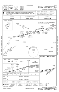


KSOW - Show Low Rgnl
Located in Show Low, United States
ICAO - SOW, IATA - SOW
Data provided by AirmateGeneral information
Coordinates: N34°15'56" W110°0'20"
Elevation is 6415 feet MSL.
Magnetic variation is 10° East View others Airports in Arizona
Operational data
Special qualification required
Current time UTC:
Current local time:
Weather
METAR: KSOW 190755Z AUTO 17005KT 10SM CLR 11/M05 A3014 RMK AO2
Communications frequencies: [VIEW]
Runways:
| RWY identifier | QFU | Length (ft) | Width (ft) | Surface | LDA (ft) |
| 04 | 48° | 3938 | 60 | ASPH | 3938 |
| 22 | 228° | 3938 | 60 | ASPH | 3938 |
| 07 | 76° | 7202 | 100 | ASPH | 6500 |
| 25 | 256° | 7202 | 100 | ASPH | 7200 |
Airport contact information
Address: Show Low United States