


KSMX - Santa Maria Pub/Capt G Allan Hancock Fld
Located in Santa Maria, United States
ICAO - SMX, IATA - SMX
Data provided by AirmateGeneral information
Coordinates: N34°53'60" W120°27'29"
Elevation is 261 feet MSL.
Magnetic variation is 14° East View others Airports in California
Operational data
Special qualification required
Current time UTC:
Current local time:
Weather
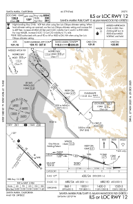
METAR: KSMX 201351Z 32005KT 5SM BR OVC005 11/11 A3004 RMK AO2 SLP174 T01110111 $
TAF: KSMX 201305Z 2013/2112 VRB03KT 5SM BR OVC005 FM201500 VRB03KT 6SM BR OVC006 FM201800 30006KT P6SM SCT010 FM202000 31012KT P6SM SKC FM210400 VRB03KT P6SM SKC
Communications frequencies: [VIEW]
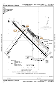
Runways:
| RWY identifier | QFU | Length (ft) | Width (ft) | Surface | LDA (ft) |
| 02 | 36° | 5199 | 75 | ASPH | 5199 |
| 20 | 216° | 5199 | 75 | ASPH | 5199 |
| 12 | 135° | 8004 | 150 | ASPH | 8004 |
| 30 | 315° | 8004 | 150 | ASPH | 8004 |
Airport contact information
Address: Santa Maria United States