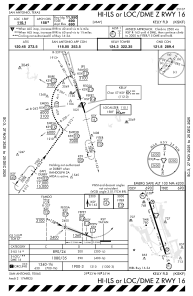
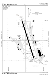


KSKF - Kelly Fld
Located in San Antonio, United States
ICAO - SKF, IATA - SKF
Data provided by AirmateGeneral information
Coordinates: N29°23'3" W98°34'52"
Elevation is 690 feet MSL.
Magnetic variation is 04° East View others Airports in Texas
Operational data
Special qualification required
Current time UTC:
Current local time:
Weather
METAR: KSKF 240930Z AUTO 16007KT 8SM OVC006 22/20 A2997 RMK AO2 SLP143 $
TAF: TAF KSKF 240200Z 2402/2508 13008KT 9999 BKN020 QNH2996INS BECMG 2403/2404 14006KT 9999 BKN015 OVC020 QNH2999INS BECMG 2406/2407 14006KT 8000 BR OVC008 QNH2997INS TEMPO 2410/2414 4800 BR OVC006 BECMG 2415/2416 15008KT 9999 NSW OVC015 QNH3004INS BECMG 2417/2418 14010G15KT 9999 BKN020 QNH2995INS BECMG 2420/2421 14012G20KT 9999 BKN040 QNH2993INS BECMG 2502/2503 13012G22KT 9999 BKN020 QNH2999INS BECMG 2505/2506 14012KT 9999 OVC010 QNH2997INS TX29/2422Z TN20/2407Z
Communications frequencies: [VIEW]
Runways:
| RWY identifier | QFU | Length (ft) | Width (ft) | Surface | LDA (ft) |
| 16 | 162° | 11550 | 150 | CONC | |
| 34 | 342° | 11550 | 150 | CONC |
Airport contact information
Address: San Antonio United States