


KSIK - Sikeston Meml Muni
Located in Sikeston, United States
ICAO - SIK, IATA -
Data provided by AirmateGeneral information
Coordinates: N36°53'56" W89°33'42"
Elevation is 314 feet MSL.
Magnetic variation is -02° East View others Airports in Missouri
Operational data
Special qualification required
Current time UTC:
Current local time:
Communications frequencies: [VIEW]
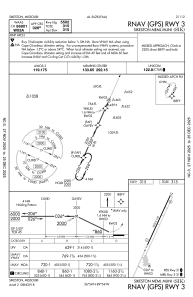
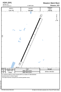
Runways:
| RWY identifier | QFU | Length (ft) | Width (ft) | Surface | LDA (ft) |
| 03 | 24° | 5502 | 100 | ASPH | |
| 21 | 204° | 5502 | 100 | ASPH |
Airport contact information
Address: Sikeston United States