
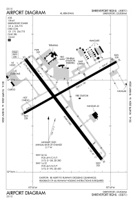


KSHV - Shreveport Rgnl
Located in Shreveport, United States
ICAO - SHV, IATA - SHV
Data provided by AirmateGeneral information
Coordinates: N32°26'47" W93°49'34"
Elevation is 257 feet MSL.
Magnetic variation is 02° East View others Airports in Louisiana
Operational data
Special qualification required
Current time UTC:
Current local time:
Weather
METAR: KSHV 191714Z 30007KT 9SM OVC010 23/19 A3007
TAF: KSHV 191720Z 1918/2018 03008KT P6SM OVC015 FM200300 04010KT P6SM OVC010 FM200900 03008KT 6SM BR VCSH OVC007 FM201200 05012KT 4SM -TSRA BR OVC005CB FM201500 03009KT 2SM -TSRA BR OVC004CB
Communications frequencies: [VIEW]
Runways:
| RWY identifier | QFU | Length (ft) | Width (ft) | Surface | LDA (ft) |
| 06 | 61° | 7003 | 150 | ASPH | 7003 |
| 24 | 241° | 7003 | 150 | ASPH | 7003 |
| 14 | 143° | 8348 | 200 | ASPH | 8118 |
| 32 | 323° | 8348 | 200 | ASPH | 7975 |
Airport contact information
Address: Shreveport United States