


KSGF - Springfield-Branson Ntl
Located in Springfield, United States
ICAO - SGF, IATA - SGF
Data provided by AirmateGeneral information
Coordinates: N37°14'44" W93°23'19"
Elevation is 1268 feet MSL.
Magnetic variation is 03° East View others Airports in Missouri
Operational data
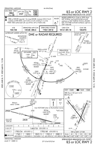
Special qualification required
Current time UTC:
Current local time:
Weather
METAR: KSGF 261852Z 17019G29KT 10SM FEW013 SCT075 16/14 A2974 RMK AO2 PK WND 18030/1815 LTG DSNT E AND SW SLP066 T01610144
TAF: KSGF 261738Z 2618/2718 17023G35KT P6SM SCT030 OVC090 FM262000 17021G33KT 4SM TSRA BR BKN013 OVC030CB TEMPO 2621/2624 1SM TSRA BR OVC009CB FM270000 18020G32KT 4SM -SHRA BKN035 PROB30 2700/2704 2SM TSRA BR BKN015 OVC070CB FM270400 18020G30KT P6SM BKN025 FM271300 18017G25KT P6SM BKN026 FM271700 19019G29KT P6SM BKN035
Communications frequencies: [VIEW]
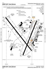
Runways:
| RWY identifier | QFU | Length (ft) | Width (ft) | Surface | LDA (ft) |
| 02 | 22° | 7003 | 150 | CONC | 7003 |
| 20 | 202° | 7003 | 150 | CONC | 7003 |
| 14 | 142° | 8000 | 150 | CONC | 8000 |
| 32 | 322° | 8000 | 150 | CONC | 8000 |
Airport contact information
Address: Springfield United States

