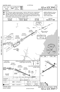
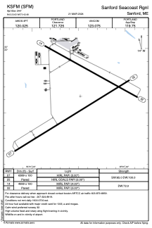


KSFM - Sanford Seacoast Rgnl
Located in Sanford, United States
ICAO - SFM, IATA -
Data provided by AirmateGeneral information
Coordinates: N43°23'38" W70°42'29"
Elevation is 244 feet MSL.
Magnetic variation is -17° East View others Airports in Maine
Operational data
Special qualification required
Current time UTC:
Current local time:
Weather
METAR: KSFM 240156Z AUTO 00000KT 10SM CLR 06/M01 A3000 RMK AO2 SLP163 T00611006 $
Communications frequencies: [VIEW]
Runways:
| RWY identifier | QFU | Length (ft) | Width (ft) | Surface | LDA (ft) |
| 07 | 58° | 6389 | 100 | ASPH | |
| 25 | 238° | 6389 | 100 | ASPH | |
| 14 | 119° | 4999 | 100 | ASPH | |
| 32 | 299° | 4999 | 100 | ASPH |
Airport contact information
Address: Sanford United States
