


KSBX - Shelby
Located in Shelby, United States
ICAO - SBX, IATA - SBX
Data provided by AirmateGeneral information
Coordinates: N48°32'26" W111°52'17"
Elevation is 3442 feet MSL.
Magnetic variation is 15° East View others Airports in Montana
Operational data
Special qualification required
Current time UTC:
Current local time:
Weather at : KCTB - Cut Bank Intl ( 38 km )
METAR: KCTB 161556Z AUTO 25021G29KT 10SM SCT065 09/M06 A2990 RMK AO2 PK WND 25029/1555 SLP124 T00891056
TAF: KCTB 161120Z 1612/1712 29011KT P6SM SCT080 BKN130 FM161500 26025G38KT P6SM SCT060 BKN100 FM162200 33020G33KT P6SM SCT030 BKN060 PROB30 1701/1706 35033G45KT 1SM -SN BKN010 FM170600 33028G43KT 3SM -SN BLSN SCT005 BKN015
Communications frequencies: [VIEW]
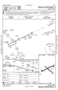
Runways:
| RWY identifier | QFU | Length (ft) | Width (ft) | Surface | LDA (ft) |
| 05 | 65° | 5005 | 75 | ASPH | |
| 23 | 245° | 5005 | 75 | ASPH | |
| 11 | 129° | 3701 | 60 | ASPH | |
| 29 | 309° | 3701 | 60 | ASPH |
Airport contact information
Address: Shelby United States