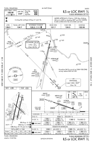
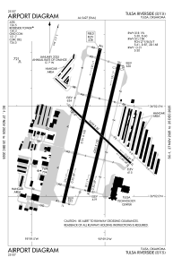


KRVS - Tulsa Riverside
Located in Tulsa, United States
ICAO - RVS, IATA -
Data provided by AirmateGeneral information
Coordinates: N36°2'23" W95°59'5"
Elevation is 637 feet MSL.
Magnetic variation is 03° East View others Airports in Oklahoma
Operational data
Special qualification required
Current time UTC:
Current local time:
Weather
TAF: KRVS 251730Z 2518/2618 15012G22KT P6SM SCT025 BKN050 TEMPO 2518/2520 BKN025 FM260100 14013G20KT P6SM VCSH BKN025 FM260600 16015G23KT P6SM VCSH BKN015 BKN025 WS020/17045KT FM261000 18015G25KT 5SM -SHRA VCTS OVC015CB PROB30 2610/2613 VRB35G45KT 1SM +TSRA BKN008CB FM261400 19018G28KT P6SM BKN025
Communications frequencies: [VIEW]
Runways:
| RWY identifier | QFU | Length (ft) | Width (ft) | Surface | LDA (ft) |
| 01R | 13° | 4208 | 100 | ASPH | 4208 |
| 19L | 193° | 4208 | 100 | ASPH | 4066 |
| 01L | 13° | 5102 | 100 | ASPH | 5102 |
| 19R | 193° | 5102 | 100 | ASPH | 5102 |
| 13 | 133° | 2641 | 50 | ASPH | 2641 |
| 31 | 313° | 2641 | 50 | ASPH | 2641 |
Airport contact information
Address: Tulsa United States
Other aviation service providers
Flight schools

Atp Flight School (800-All-Atps)
Atp Flight School (800-All-Atps)
info@atpflightschool.com+1(800)255-2877
Christiansen Aviation Flight School
Christiansen Aviation Flight School
flightinfo@christiansenaviation.com+1(918)299-2646