


KRKS - Southwest Wyoming Rgnl
Located in Rock Springs, United States
ICAO - RKS, IATA - RKS
Data provided by AirmateGeneral information
Coordinates: N41°35'39" W109°3'55"
Elevation is 6764 feet MSL.
Magnetic variation is 13° East View others Airports in Wyoming
Operational data
Special qualification required
Current time UTC:
Current local time:
Weather
METAR: KRKS 071654Z AUTO 27024G34KT 9SM -SN FEW022 BKN046 OVC060 04/M03 A2970 RMK AO2 PK WND 26034/1647 UPB25E35RAB35E51SNB51 SLP050 P0000 T00391033
TAF: KRKS 071134Z 0712/0812 25015G25KT P6SM OVC050 FM071500 28025G35KT P6SM OVC060 FM071900 28030G40KT P6SM BKN080
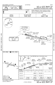
Communications frequencies: [VIEW]
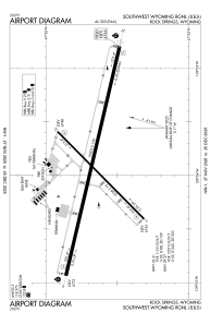
Runways:
| RWY identifier | QFU | Length (ft) | Width (ft) | Surface | LDA (ft) |
| 03 | 45° | 5228 | 75 | ASPH | 5228 |
| 21 | 225° | 5228 | 75 | ASPH | 5228 |
| 09 | 103° | 10000 | 150 | ASPH | 10000 |
| 27 | 283° | 10000 | 150 | ASPH | 10000 |
Airport contact information
Address: Rock Springs United States