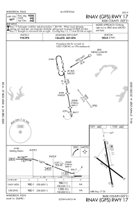
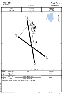


KRFI - Rusk County
Located in Henderson, United States
ICAO - RFI, IATA -
Data provided by AirmateGeneral information
Coordinates: N32°8'30" W94°51'6"
Elevation is 442 feet MSL.
Magnetic variation is 03° East View others Airports in Texas
Operational data
Special qualification required
Current time UTC:
Current local time:
Communications frequencies: [VIEW]
Runways:
| RWY identifier | QFU | Length (ft) | Width (ft) | Surface | LDA (ft) |
| 12 | 126° | 3002 | 75 | ASPH | |
| 30 | 306° | 3002 | 75 | ASPH | |
| 17 | 170° | 4006 | 75 | ASPH | |
| 35 | 350° | 4006 | 75 | ASPH |
Airport contact information
Address: Henderson United States