


KRDD - Redding Rgnl
Located in Redding, United States
ICAO - RDD, IATA - RDD
Data provided by AirmateGeneral information
Coordinates: N40°30'32" W122°17'36"
Elevation is 504 feet MSL.
Magnetic variation is 14° East View others Airports in California
Operational data
Special qualification required
Current time UTC:
Current local time:
Weather
METAR: KRDD 060053Z 17014KT 10SM SCT080 17/04 A2998 RMK AO2 SLP150 T01670039
TAF: KRDD 052339Z 0600/0624 16012KT P6SM SCT060 SCT080 FM060600 VRB04KT P6SM BKN100
Communications frequencies: [VIEW]
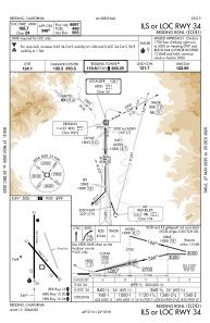
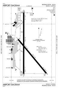
Runways:
| RWY identifier | QFU | Length (ft) | Width (ft) | Surface | LDA (ft) |
| 12 | 140° | 5067 | 150 | ASPH | 5067 |
| 30 | 320° | 5067 | 150 | ASPH | 5067 |
| 16 | 180° | 7003 | 150 | ASPH | 7003 |
| 34 | 0° | 7003 | 150 | ASPH | 7003 |
Airport contact information
Address: Redding United States

