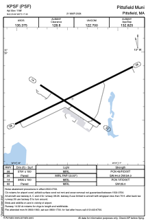


KPSF - Pittsfield Muni
Located in Pittsfield, United States
ICAO - PSF, IATA -
Data provided by AirmateGeneral information
Coordinates: N42°25'39" W73°17'27"
Elevation is 1188 feet MSL.
Magnetic variation is -15° East View others Airports in Massachusetts
Operational data
Special qualification required
Current time UTC:
Current local time:
Weather
METAR: KPSF 290854Z AUTO 31008KT 9SM BKN006 OVC010 16/15 A2998 RMK AO2 SLP131 T01610150 56001
TAF: KPSF 290812Z 2908/3006 29009KT P6SM FEW009 SCT012 TEMPO 2908/2909 BKN005 OVC012 FM290900 33007KT P6SM BKN018 FM291500 32005KT P6SM SCT050 FM292300 VRB03KT P6SM SCT035
Communications frequencies: [VIEW]
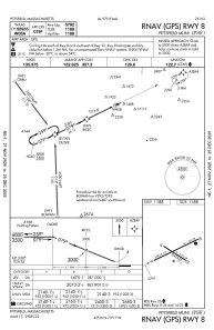
Runways:
| RWY identifier | QFU | Length (ft) | Width (ft) | Surface | LDA (ft) |
| 08 | 64° | 5791 | 100 | ASPH | |
| 26 | 244° | 5791 | 100 | ASPH | |
| 14 | 123° | 3496 | 100 | ASPH | |
| 32 | 303° | 3496 | 100 | ASPH |
Airport contact information
Address: Pittsfield United States
