


KPOV - Portage County
Located in Ravenna, United States
ICAO - POV, IATA -
Data provided by AirmateGeneral information
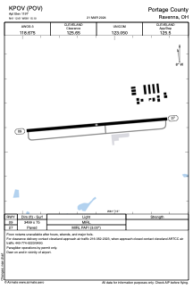
Coordinates: N41°12'37" W81°15'6"
Elevation is 1197 feet MSL.
Magnetic variation is -08° East View others Airports in Ohio
Operational data
Special qualification required
Current time UTC:
Current local time:
Weather
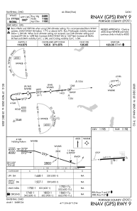
METAR: KPOV 240635Z AUTO 26006KT 10SM SCT017 BKN025 OVC032 09/08 A2986 RMK AO2 T00900075 PWINO
Communications frequencies: [VIEW]
Runways:
| RWY identifier | QFU | Length (ft) | Width (ft) | Surface | LDA (ft) |
| 09 | 85° | 3499 | 75 | ASPH | |
| 27 | 265° | 3499 | 75 | ASPH |
Airport contact information
Address: Ravenna United States