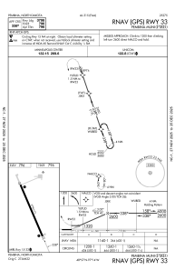
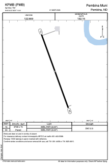


KPMB - Pembina Muni
Located in Pembina, United States
ICAO - PMB, IATA - PMB
Data provided by AirmateGeneral information
Coordinates: N48°56'33" W97°14'26"
Elevation is 795 feet MSL.
Magnetic variation is 03° East View others Airports in North Dakota
Operational data
Special qualification required
Current time UTC:
Current local time:
Weather at : KHCO - Hallock Muni ( 30 km )
METAR: KHCO 250835Z AUTO 14009KT 10SM CLR 03/M03 A3002 RMK AO2
Communications frequencies: [VIEW]
Runways:
| RWY identifier | QFU | Length (ft) | Width (ft) | Surface | LDA (ft) |
| 15 | 160° | 3798 | 75 | ASPH | |
| 33 | 340° | 3798 | 75 | ASPH |
Airport contact information
Address: Pembina United States