


KPIL - Port Isabel-Cameron County
Located in Port Isabel, United States
ICAO - PIL, IATA -
Data provided by AirmateGeneral information
Coordinates: N26°9'58" W97°20'45"
Elevation is 18 feet MSL.
Magnetic variation is 05° East View others Airports in Texas
Operational data
Special qualification required
Current time UTC:
Current local time:
Weather
METAR: KPIL 201253Z AUTO 16007KT 7SM OVC039 26/23 A2997 RMK AO2 SLP147 T02560228
Communications frequencies: [VIEW]
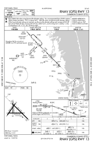
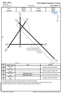
Runways:
| RWY identifier | QFU | Length (ft) | Width (ft) | Surface | LDA (ft) |
| 03 | 35° | 5000 | 150 | OTHER | |
| 21 | 215° | 5000 | 150 | OTHER | |
| 08 | 90° | 5317 | 150 | CONC | |
| 26 | 270° | 5317 | 150 | CONC | |
| 13 | 135° | 8001 | 200 | OTHER | |
| 31 | 315° | 8001 | 200 | OTHER | |
| 17 | 180° | 4200 | 75 | OTHER | |
| 35 | 360° | 4200 | 75 | OTHER |
Airport contact information
Address: Port Isabel United States