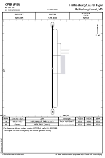


KPIB - Hattiesburg/Laurel Rgnl
Located in Hattiesburg-Laurel, United States
ICAO - PIB, IATA - PIB
Data provided by AirmateGeneral information
Coordinates: N31°28'2" W89°20'13"
Elevation is 297 feet MSL.
Magnetic variation is -01° East View others Airports in Mississippi
Operational data
Special qualification required
Current time UTC:
Current local time:
Weather
METAR: KPIB 280656Z AUTO 09004KT 10SM CLR 17/16 A3008 RMK AO2 SLP182 T01670161 PNO $
TAF: KPIB 280526Z 2806/2906 00000KT P6SM SKC FM281100 12009G20KT P6SM BKN015 FM281600 15015G23KT P6SM BKN035 FM290200 14009KT P6SM BKN020
Communications frequencies: [VIEW]
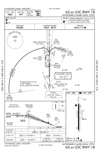
Runways:
| RWY identifier | QFU | Length (ft) | Width (ft) | Surface | LDA (ft) |
| 18 | 180° | 6502 | 150 | ASPH | 6502 |
| 36 | 360° | 6502 | 150 | ASPH | 6502 |
Airport contact information
Address: Hattiesburg-Laurel United States