


KPHX - Phoenix Sky Harbor Intl
Located in Phoenix, United States
ICAO - PHX, IATA - PHX
Data provided by AirmateGeneral information
Coordinates: N33°26'3" W112°0'42"
Elevation is 1134 feet MSL.
Magnetic variation is 12° East View others Airports in Arizona
Operational data
Special qualification required
Current time UTC:
Current local time:
Weather
METAR: KPHX 262051Z 25015G25KT 10SM FEW075 SCT110 BKN270 27/06 A2970 RMK AO2 PK WND 24031/2008 SLP040 T02720061 56015
TAF: KPHX 262040Z 2621/2724 26016G26KT P6SM SCT080 TEMPO 2700/2704 25023G33KT FM270400 25016G24KT P6SM SCT080 FM270700 26010G18KT P6SM FEW080 FM271600 25007KT P6SM FEW090 FM271900 25012G20KT P6SM SCT090
Communications frequencies: [VIEW]
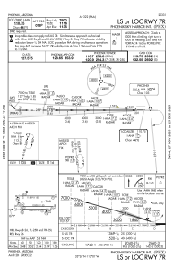
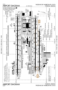
Runways:
| RWY identifier | QFU | Length (ft) | Width (ft) | Surface | LDA (ft) |
| 07R | 90° | 7800 | 150 | CONC | 7800 |
| 25L | 270° | 7800 | 150 | CONC | 7800 |
| 07L | 90° | 10300 | 150 | CONC | 10300 |
| 25R | 270° | 10300 | 150 | CONC | 10300 |
| 08 | 90° | 11489 | 150 | CONC | 10591 |
| 26 | 270° | 11489 | 150 | CONC | 11489 |
Airport contact information
Address: Phoenix United States
