


KORH - Worcester Rgnl
Located in Worcester, United States
ICAO - ORH, IATA - ORH
Data provided by AirmateGeneral information
Coordinates: N42°16'2" W71°52'32"
Elevation is 1009 feet MSL.
Magnetic variation is -15° East View others Airports in Massachusetts
Operational data
Special qualification required
Current time UTC:
Current local time:
Weather
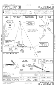
METAR: KORH 231454Z 21004KT 10SM CLR 13/M07 A3014 RMK AO2 SLP210 T01331072 58010
TAF: KORH 231120Z 2312/2412 25004KT P6SM SKC FM231500 19009KT P6SM SKC
Communications frequencies: [VIEW]
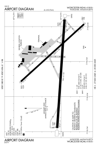
Runways:
| RWY identifier | QFU | Length (ft) | Width (ft) | Surface | LDA (ft) |
| 11 | 94° | 7001 | 150 | ASPH | 7001 |
| 29 | 274° | 7001 | 150 | ASPH | 7001 |
| 15 | 138° | 5000 | 100 | ASPH | 5000 |
| 33 | 318° | 5000 | 100 | ASPH | 5000 |
Airport contact information
Address: Worcester United States
