


KOMH - Orange County
Located in Orange, United States
ICAO - OMH, IATA -
Data provided by AirmateGeneral information
Coordinates: N38°14'50" W78°2'44"
Elevation is 464 feet MSL.
Magnetic variation is -09° East View others Airports in Virginia
Operational data
Special qualification required
Current time UTC:
Current local time:
Weather
METAR: KOMH 192135Z AUTO 12004KT 10SM OVC010 13/11 A3003 RMK AO2
Communications frequencies: [VIEW]
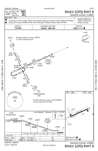
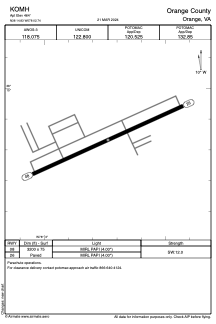
Runways:
| RWY identifier | QFU | Length (ft) | Width (ft) | Surface | LDA (ft) |
| 08 | 66° | 3200 | 75 | ASPH | |
| 26 | 246° | 3200 | 75 | ASPH |
Airport contact information
Address: Orange United States