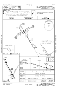


KOLU - Columbus Muni
Located in Columbus, United States
ICAO - OLU, IATA -
Data provided by AirmateGeneral information
Coordinates: N41°26'55" W97°20'27"
Elevation is 1447 feet MSL.
Magnetic variation is 08° East View others Airports in Nebraska
Operational data
Special qualification required
Current time UTC:
Current local time:
Weather
METAR: KOLU 200556Z AUTO 33009KT 10SM CLR 03/M04 A3040 RMK AO2 SLP305 T00281044 10094 20028 401221022 51018
Communications frequencies: [VIEW]
Runways:
| RWY identifier | QFU | Length (ft) | Width (ft) | Surface | LDA (ft) |
| 02 | 30° | 4135 | 150 | GRASS | |
| 20 | 210° | 4135 | 150 | GRASS | |
| 14 | 150° | 6801 | 100 | CONC | 6260 |
| 32 | 330° | 6801 | 100 | CONC | 5850 |
Airport contact information
Address: Columbus United States
