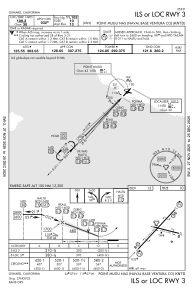
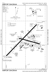


KNTD - Point Mugu Nas (Naval Base Ventura Co)
Located in Oxnard, United States
ICAO - NTD, IATA -
Data provided by AirmateGeneral information
Coordinates: N34°7'9" W119°7'11"
Elevation is 13 feet MSL.
Magnetic variation is 12° East View others Airports in California
Operational data
Special qualification required
Current time UTC:
Current local time:
Weather
METAR: KNTD 060555Z 03003KT 10SM CLR 11/08 A3000 RMK AO2 SLP160 6//// T01110078 10172 20094 51020 PNO $
TAF: TAF KNTD 0523/0623 28020G27KT 9999 FEW035 FEW065 SCT200 540309 QNH2988INS FM060300 30014G21KT 9999 FEW200 540309 QNH2992INS FM060700 VRB06KT 9999 SKC 500000 QNH2995INS AUTOMATED SENSOR METWATCH 0606Z TIL 0613Z TX18/0620Z TN06/0613Z FS30205
Communications frequencies: [VIEW]
Runways:
| RWY identifier | QFU | Length (ft) | Width (ft) | Surface | LDA (ft) |
| 03 | 44° | 11102 | 200 | OTHER | |
| 21 | 224° | 11102 | 200 | OTHER | |
| 09 | 105° | 5502 | 200 | OTHER | |
| 27 | 285° | 5502 | 200 | OTHER |
Airport contact information
Address: Oxnard United States