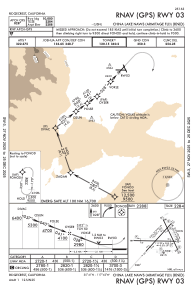
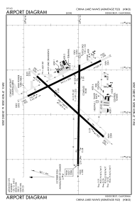


KNID - China Lake Naws (Armitage Fld)
Located in China Lake, United States
ICAO - NID, IATA -
Data provided by AirmateGeneral information
Coordinates: N35°41'9" W117°41'32"
Elevation is 2284 feet MSL.
Magnetic variation is 14° East View others Airports in California
Operational data
Special qualification required
Current time UTC:
Current local time:
Weather
METAR: KNID 191056Z AUTO 13004KT 10SM CLR 14/02 A2983 RMK AO2 SLP086 T01390017 $
TAF: TAF AMD KNID 1907/1923 VRB05KT 9999 SCT220 QNH2982INS TEMPO 1910/1916 20007KT 9999 SCT160 BKN220 BECMG 1921/1923 20012G20KT 9999 FEW200 SCT250 QNH2976INS LAST NO AMDS AFT 1907 NEXT 1915 TN12/1914Z TX32/1923Z AMD 0704
Communications frequencies: [VIEW]
Runways:
| RWY identifier | QFU | Length (ft) | Width (ft) | Surface | LDA (ft) |
| 03 | 42° | 10001 | 200 | CONC | |
| 21 | 222° | 10001 | 200 | CONC | |
| 08 | 90° | 7111 | 75 | CONC | |
| 26 | 270° | 7111 | 75 | CONC | |
| 14 | 154° | 9014 | 200 | ASPH | |
| 32 | 334° | 9014 | 200 | ASPH |
Airport contact information
Address: China Lake United States