


KNGU - Norfolk Ns (Chambers Fld)
Located in Norfolk, United States
ICAO - NGU, IATA -
Data provided by AirmateGeneral information
Coordinates: N36°56'15" W76°17'21"
Elevation is 14 feet MSL.
Magnetic variation is -10° East View others Airports in Virginia
Operational data
Special qualification required
Current time UTC:
Current local time:
Weather
METAR: KNGU 260359Z 05011KT 9SM FEW016 BKN026 11/07 A3032 RMK AO2 SLP265 T01060067
TAF: TAF KNGU 2523/2623 05015G25KT 9999 OVC020 540009 QNH3026INS TEMPO 2523/2603 OVC010 05010G17KT FM260300 06010G17KT 9999 BKN015 BKN030 500000 QNH3029INS TEMPO 2603/2607 OVC007 FM260700 06009KT 9999 SCT015 BKN035 QNH3030INS TEMPO 2307/2612 BKN010 OVC030 FM261500 07009KT 9999 FEW020 BKN050 QNH3040INS FM262000 08011G18KT 9999 FEW050 SCT100 QNH3042INS TX15/2619Z TN09/2611Z FN00062
Communications frequencies: [VIEW]
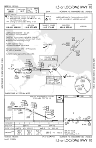
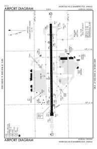
Runways:
| RWY identifier | QFU | Length (ft) | Width (ft) | Surface | LDA (ft) |
| 10 | 90° | 8370 | 200 | ASPH | 8071 |
| 28 | 270° | 8370 | 200 | ASPH | 7375 |
Airport contact information
Address: Norfolk United States