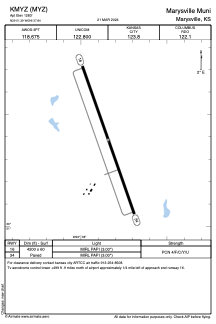


KMYZ - Marysville Muni
Located in Marysville, United States
ICAO - MYZ, IATA -
Data provided by AirmateGeneral information
Coordinates: N39°51'23" W96°37'51"
Elevation is 1283 feet MSL.
Magnetic variation is 04° East View others Airports in Kansas
Operational data
Special qualification required
Current time UTC:
Current local time:
Weather
METAR: KMYZ 191955Z AUTO 31007KT 10SM OVC100 14/M01 A3026 RMK AO2
Communications frequencies: [VIEW]
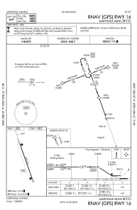
Runways:
| RWY identifier | QFU | Length (ft) | Width (ft) | Surface | LDA (ft) |
| 16 | 161° | 4200 | 60 | ASPH | |
| 34 | 341° | 4200 | 60 | ASPH |
Airport contact information
Address: Marysville United States