


KMYR - Myrtle Beach Intl
Located in Myrtle Beach, United States
ICAO - MYR, IATA - MYR
Data provided by AirmateGeneral information
Coordinates: N33°40'47" W78°55'42"
Elevation is 25 feet MSL.
Magnetic variation is -09° East View others Airports in South Carolina
Operational data
Special qualification required
Current time UTC:
Current local time:
Weather
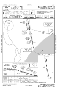
METAR: KMYR 041056Z 14006KT 10SM OVC024 23/22 A3008 RMK AO2 SLP186 T02280222
TAF: KMYR 041120Z 0412/0512 15004KT P6SM BKN030 BKN120 OVC250 FM041600 15010KT P6SM SCT030 BKN150 FM042300 14007KT P6SM BKN120 FM050800 16005KT P6SM VCSH BKN040 OVC100
Communications frequencies: [VIEW]
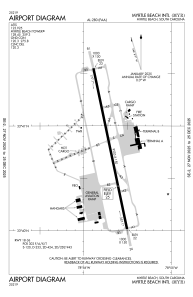
Runways:
| RWY identifier | QFU | Length (ft) | Width (ft) | Surface | LDA (ft) |
| 18 | 168° | 9503 | 150 | ASPH | |
| 36 | 348° | 9503 | 150 | ASPH |
Airport contact information
Address: Myrtle Beach United States
