
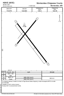


KMVE - Montevideo-Chippewa County
Located in Montevideo, United States
ICAO - MVE, IATA -
Data provided by AirmateGeneral information
Coordinates: N44°58'9" W95°42'37"
Elevation is 1034 feet MSL.
Magnetic variation is 02° East View others Airports in Minnesota
Operational data
Special qualification required
Current time UTC:
Current local time:
Weather
METAR: KMVE 261155Z AUTO 14022G28KT 7SM RA OVC029 07/06 A2974 RMK AO2 P0001
Communications frequencies: [VIEW]
Runways:
| RWY identifier | QFU | Length (ft) | Width (ft) | Surface | LDA (ft) |
| 03 | 38° | 2361 | 165 | GRASS | |
| 21 | 218° | 2361 | 165 | GRASS | |
| 14 | 143° | 3999 | 75 | ASPH | |
| 32 | 323° | 3999 | 75 | ASPH |
Airport contact information
Address: Montevideo United States