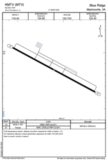


KMTV - Blue Ridge
Located in Martinsville, United States
ICAO - MTV, IATA -
Data provided by AirmateGeneral information
Coordinates: N36°37'51" W80°1'6"
Elevation is 940 feet MSL.
Magnetic variation is -07° East View others Airports in Virginia
Operational data
Special qualification required
Current time UTC:
Current local time:
Weather
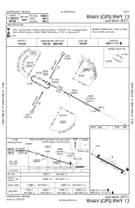
METAR: KMTV 200415Z AUTO 31003KT 3SM BR OVC021 15/14 A3005 RMK AO2 T01470135
Communications frequencies: [VIEW]
Runways:
| RWY identifier | QFU | Length (ft) | Width (ft) | Surface | LDA (ft) |
| 13 | 118° | 5002 | 100 | ASPH | |
| 31 | 298° | 5002 | 100 | ASPH |
Airport contact information
Address: Martinsville United States