


KMSO - Missoula Montana
Located in Missoula, United States
ICAO - MSO, IATA - MSO
Data provided by AirmateGeneral information
Coordinates: N46°54'59" W114°5'26"
Elevation is 3205 feet MSL.
Magnetic variation is 13° East View others Airports in Montana
Operational data
Special qualification required
Current time UTC:
Current local time:
Weather
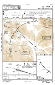
METAR: KMSO 011653Z 14003KT 10SM FEW046 BKN060 OVC090 04/M01 A3000 RMK AO2 SLP180 T00441011
TAF: KMSO 011120Z 0112/0212 VRB03KT P6SM VCSH BKN060 FM011500 27011G21KT 6SM -SHSNRA OVC035 FM011900 29015G25KT P6SM VCSH BKN050 FM020200 30008KT P6SM VCSH BKN070
Communications frequencies: [VIEW]
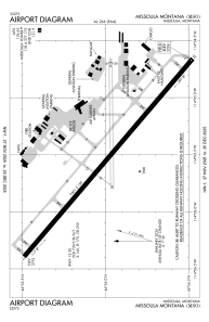
Runways:
| RWY identifier | QFU | Length (ft) | Width (ft) | Surface | LDA (ft) |
| 08 | 89° | 4612 | 75 | ASPH | 4612 |
| 26 | 269° | 4612 | 75 | ASPH | 4612 |
| 12 | 130° | 9501 | 150 | ASPH | 9501 |
| 30 | 310° | 9501 | 150 | ASPH | 9501 |
Airport contact information
Address: Missoula United States

