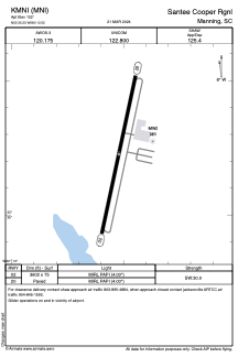


KMNI - Santee Cooper Rgnl
Located in Manning, United States
ICAO - MNI, IATA -
Data provided by AirmateGeneral information
Coordinates: N33°35'14" W80°12'31"
Elevation is 102 feet MSL.
Magnetic variation is -06° East View others Airports in South Carolina
Operational data
Special qualification required
Current time UTC:
Current local time:
Weather
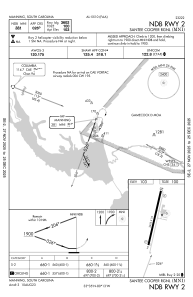
METAR: KMNI 242215Z AUTO 24009G15KT 10SM SCT070 SCT075 25/11 A3000 RMK AO2
Communications frequencies: [VIEW]
Runways:
| RWY identifier | QFU | Length (ft) | Width (ft) | Surface | LDA (ft) |
| 02 | 12° | 3602 | 75 | ASPH | |
| 20 | 192° | 3602 | 75 | ASPH |
Airport contact information
Address: Manning United States