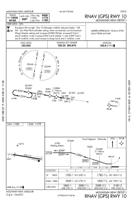
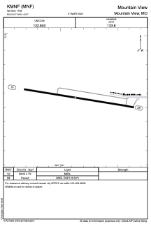


KMNF - Mountain View
Located in Mountain View, United States
ICAO - MNF, IATA -
Data provided by AirmateGeneral information
Coordinates: N36°59'34" W91°42'52"
Elevation is 1182 feet MSL.
Magnetic variation is -00° East View others Airports in Missouri
Operational data
Special qualification required
Current time UTC:
Current local time:
Weather at : KUNO - West Plains Rgnl ( 21 km )
METAR: KUNO 231053Z AUTO 18005KT 10SM CLR 09/02 A3000 RMK AO2 SLP155 T00890022
Communications frequencies: [VIEW]
Runways:
| RWY identifier | QFU | Length (ft) | Width (ft) | Surface | LDA (ft) |
| 10 | 99° | 5005 | 75 | ASPH | |
| 28 | 279° | 5005 | 75 | ASPH |
Airport contact information
Address: Mountain View United States