


KMKT - Mankato Rgnl
Located in Mankato, United States
ICAO - MKT, IATA -
Data provided by AirmateGeneral information
Coordinates: N44°13'22" W93°55'10"
Elevation is 1020 feet MSL.
Magnetic variation is 04° East View others Airports in Minnesota
Operational data
Special qualification required
Current time UTC:
Current local time:
Weather
METAR: KMKT 251556Z AUTO 15017G23KT 10SM CLR 17/03 A3014 RMK AO2 SLP208 T01720028
TAF: KMKT 251140Z 2512/2612 15011G23KT P6SM BKN090 FM251600 14019G29KT P6SM SCT150 FM260400 13017G26KT P6SM BKN080 FM260900 14018G28KT 6SM -SHRA BR SCT025 OVC045
Communications frequencies: [VIEW]
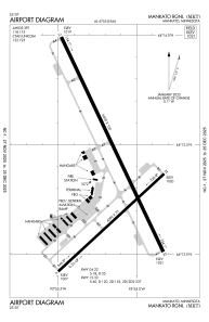
Runways:
| RWY identifier | QFU | Length (ft) | Width (ft) | Surface | LDA (ft) |
| 04 | 47° | 4000 | 75 | ASPH | |
| 22 | 227° | 4000 | 75 | ASPH | |
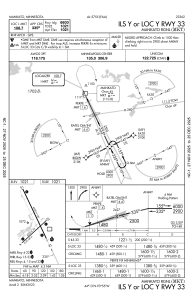
| 15 | 155° | 6600 | 100 | CONC | |
| 33 | 335° | 6600 | 100 | CONC |
Airport contact information
Address: Mankato United States

