


KMKE - General Mitchell Intl
Located in Milwaukee, United States
ICAO - MKE, IATA - MKE
Data provided by AirmateGeneral information
Coordinates: N42°56'49" W87°53'49"
Elevation is 728 feet MSL.
Magnetic variation is -04° East View others Airports in Wisconsin
Operational data
Special qualification required
Current time UTC:
Current local time:
Weather
METAR: KMKE 251952Z 09010KT 10SM FEW250 10/03 A3032 RMK AO2 SLP274 T01000028
TAF: KMKE 251720Z 2518/2624 13010KT P6SM FEW250 FM260000 10006KT P6SM FEW250 FM261300 13013G22KT P6SM BKN250 PROB30 2619/2621 6SM -SHRA BR OVC090 FM262100 13015G26KT 5SM SHRA BR OVC070
Communications frequencies: [VIEW]
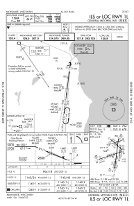
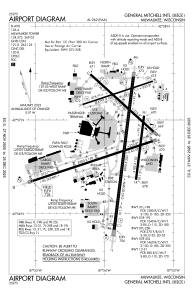
Runways:
| RWY identifier | QFU | Length (ft) | Width (ft) | Surface | LDA (ft) |
| 01R | 7° | 4182 | 150 | OTHER | 4182 |
| 19L | 187° | 4182 | 150 | OTHER | 4182 |
| 01L | 7° | 9990 | 200 | OTHER | 9080 |
| 19R | 187° | 9990 | 200 | OTHER | 9205 |
| 07R | 72° | 8300 | 150 | OTHER | 8012 |
| 25L | 252° | 8300 | 150 | OTHER | 7867 |
| 07L | 72° | 4797 | 100 | OTHER | 4797 |
| 25R | 252° | 4797 | 100 | OTHER | 4797 |
| 13 | 132° | 5537 | 150 | OTHER | 4797 |
| 31 | 312° | 5537 | 150 | OTHER | 5152 |
Airport contact information
Address: Milwaukee United States
