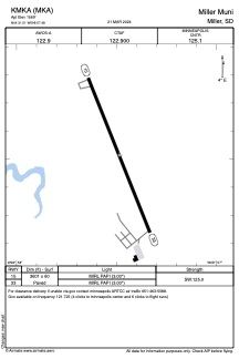


KMKA - Miller Muni
Located in Miller, United States
ICAO - MKA, IATA -
Data provided by AirmateGeneral information
Coordinates: N44°31'31" W98°57'29"
Elevation is 1569 feet MSL.
Magnetic variation is 07° East View others Airports in South Dakota
Operational data
Special qualification required
Current time UTC:
Current local time:
Communications frequencies: [VIEW]
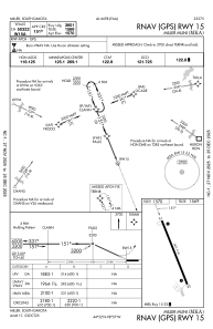
Runways:
| RWY identifier | QFU | Length (ft) | Width (ft) | Surface | LDA (ft) |
| 15 | 158° | 3601 | 60 | CONC | |
| 33 | 338° | 3601 | 60 | CONC |
Airport contact information
Address: Miller United States