


KMIE - Delaware County Rgnl
Located in Muncie, United States
ICAO - MIE, IATA - MIE
Data provided by AirmateGeneral information
Coordinates: N40°14'33" W85°23'45"
Elevation is 937 feet MSL.
Magnetic variation is -03° East View others Airports in Indiana
Operational data
Special qualification required
Current time UTC:
Current local time:
Weather
METAR: KMIE 072322Z 18010G51KT 1/4SM +TSRA BKN014 BKN025 OVC031 21/18 A2955 RMK AO2 PK WND 30051/2319 LTG DSNT NE AND S AND SW TSB08 TS OHD MOV NE P0089 T02110183
Communications frequencies: [VIEW]
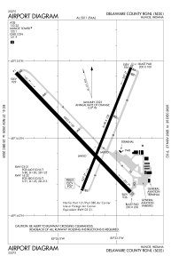
Runways:
| RWY identifier | QFU | Length (ft) | Width (ft) | Surface | LDA (ft) |
| 03 | 22° | 5198 | 100 | ASPH | 5197 |
| 21 | 202° | 5198 | 100 | ASPH | 5197 |
| 14 | 136° | 6500 | 150 | ASPH | 6500 |
| 32 | 316° | 6500 | 150 | ASPH | 6500 |
Airport contact information
Address: Muncie United States
