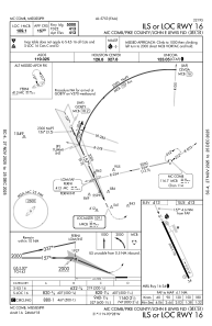
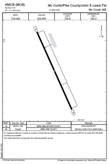


KMCB - Mc Comb/Pike County/John E Lewis Fld
Located in Mc Comb, United States
ICAO - MCB, IATA - MCB
Data provided by AirmateGeneral information
Coordinates: N31°10'42" W90°28'19"
Elevation is 413 feet MSL.
Magnetic variation is -01° East View others Airports in Mississippi
Operational data
Special qualification required
Current time UTC:
Current local time:
Weather
METAR: KMCB 260753Z AUTO 16004KT 10SM CLR 17/17 A2999 RMK AO2 SLP149 T01720167
TAF: KMCB 260521Z 2606/2706 16005KT P6SM FEW020 BKN250 TEMPO 2610/2613 3SM BR FM261600 16014KT P6SM SCT035 BKN250 FM270000 15010KT P6SM SCT025 BKN250
Communications frequencies: [VIEW]
Runways:
| RWY identifier | QFU | Length (ft) | Width (ft) | Surface | LDA (ft) |
| 16 | 156° | 5000 | 100 | ASPH | |
| 34 | 336° | 5000 | 100 | ASPH |
Airport contact information
Address: Mc Comb United States