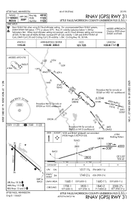


KLXL - Little Falls/Morrison County-Lindbergh Fld
Located in Little Falls, United States
ICAO - LXL, IATA -
Data provided by AirmateGeneral information
Coordinates: N45°56'57" W94°20'49"
Elevation is 1122 feet MSL.
Magnetic variation is 03° East View others Airports in Minnesota
Operational data
Special qualification required
Current time UTC:
Current local time:
Communications frequencies: [VIEW]
Runways:
| RWY identifier | QFU | Length (ft) | Width (ft) | Surface | LDA (ft) |
| 13 | 131° | 4010 | 75 | ASPH | |
| 31 | 311° | 4010 | 75 | ASPH | |
| 18 | 181° | 2858 | 60 | ASPH | 2856 |
| 36 | 1° | 2858 | 60 | ASPH | 2856 |
Airport contact information
Address: Little Falls United States