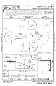
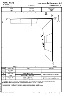


KLWV - Lawrenceville-Vincennes Intl
Located in Lawrenceville, United States
ICAO - LWV, IATA - LWV
Data provided by AirmateGeneral information
Coordinates: N38°45'51" W87°36'20"
Elevation is 429 feet MSL.
Magnetic variation is -01° East View others Airports in Illinois
Operational data
Special qualification required
Current time UTC:
Current local time:
Communications frequencies: [VIEW]
Runways:
| RWY identifier | QFU | Length (ft) | Width (ft) | Surface | LDA (ft) |
| 09 | 89° | 5198 | 100 | ASPH | |
| 27 | 269° | 5198 | 100 | ASPH | |
| 18 | 179° | 5199 | 100 | ASPH | |
| 36 | 359° | 5199 | 100 | ASPH | |
| 04U | 0° | 1000 | 200 | GRASS | |
| 22U | 0° | 1000 | 200 | GRASS |
Airport contact information
Address: Lawrenceville United States