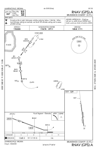
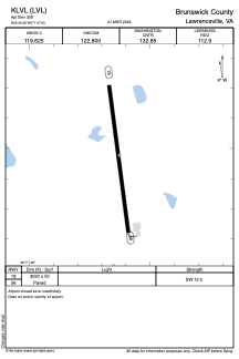


KLVL - Brunswick County
Located in Lawrenceville, United States
ICAO - LVL, IATA - LVL
Data provided by AirmateGeneral information
Coordinates: N36°46'22" W77°47'39"
Elevation is 328 feet MSL.
Magnetic variation is -08° East View others Airports in Virginia
Operational data
Special qualification required
Current time UTC:
Current local time:
Weather
METAR: KLVL 252235Z AUTO 05006KT SCT065 18/09 A3021 RMK AO1 T01770093
Communications frequencies: [VIEW]
Runways:
| RWY identifier | QFU | Length (ft) | Width (ft) | Surface | LDA (ft) |
| 06 | 57° | 1890 | 70 | GRASS | |
| 24 | 237° | 1890 | 70 | GRASS | |
| 18 | 172° | 3020 | 50 | ASPH | |
| 36 | 352° | 3020 | 50 | ASPH |
Airport contact information
Address: Lawrenceville United States