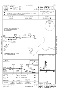
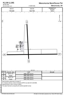


KLUM - Menomonie Muni/Score Fld
Located in Menomonie, United States
ICAO - LUM, IATA -
Data provided by AirmateGeneral information
Coordinates: N44°53'32" W91°52'4"
Elevation is 895 feet MSL.
Magnetic variation is 01° East View others Airports in Wisconsin
Operational data
Special qualification required
Current time UTC:
Current local time:
Weather
METAR: KLUM 261815Z AUTO 09016G20KT 10SM BKN042 OVC060 12/03 A2984 RMK AO2 T01150026 PWINO
Communications frequencies: [VIEW]
Runways:
| RWY identifier | QFU | Length (ft) | Width (ft) | Surface | LDA (ft) |
| 09 | 89° | 5074 | 75 | ASPH | |
| 27 | 269° | 5074 | 75 | ASPH | |
| 18 | 177° | 3470 | 75 | ASPH | |
| 36 | 357° | 3470 | 75 | ASPH |
Airport contact information
Address: Menomonie United States
