


KLQR - Larned-Pawnee County
Located in Larned, United States
ICAO - LQR, IATA -
Data provided by AirmateGeneral information
Coordinates: N38°12'31" W99°5'9"
Elevation is 2012 feet MSL.
Magnetic variation is 08° East View others Airports in Kansas
Operational data
Special qualification required
Current time UTC:
Current local time:
Weather at : KGBD - Great Bend Muni ( 25 km )
METAR: KGBD 262256Z AUTO 26019G26KT 10SM CLR 27/07 A2950 RMK AO2 PK WND 27032/2224 SLP970 T02670072
TAF: KGBD 262320Z 2700/2724 26019G26KT P6SM SKC FM270200 20005KT P6SM FEW250 FM271400 17011KT P6SM SCT110 FM272000 18012KT P6SM SCT040 PROB30 2722/2724 23030G45KT 2SM +TSRA BR OVC010CB
Communications frequencies: [VIEW]
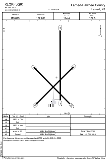
Runways:
| RWY identifier | QFU | Length (ft) | Width (ft) | Surface | LDA (ft) |
| 04 | 45° | 2860 | 170 | GRASS | |
| 22 | 225° | 2860 | 170 | GRASS | |
| 12 | 135° | 2830 | 180 | GRASS | |
| 30 | 315° | 2830 | 180 | GRASS | |
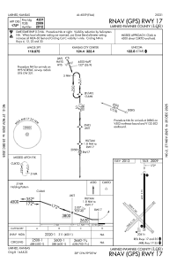
| 17 | 180° | 4201 | 75 | CONC | |
| 35 | 360° | 4201 | 75 | CONC |
Airport contact information
Address: Larned United States