


KLOL - Derby Fld
Located in Lovelock, United States
ICAO - LOL, IATA - LOL
Data provided by AirmateGeneral information
Coordinates: N40°3'59" W118°33'54"
Elevation is 3907 feet MSL.
Magnetic variation is 14° East View others Airports in Nevada
Operational data
Special qualification required
Current time UTC:
Current local time:
Weather
METAR: KLOL 161753Z AUTO 00000KT 10SM CLR 14/03 A3017 RMK AO2 SLP207 T01390028 10139 21006 58005
Communications frequencies: [VIEW]
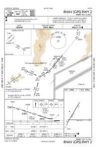
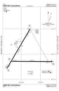
Runways:
| RWY identifier | QFU | Length (ft) | Width (ft) | Surface | LDA (ft) |
| 02 | 30° | 5529 | 75 | ASPH | |
| 08 | 90° | 4931 | 75 | ASPH | |
| 20 | 210° | 5529 | 75 | ASPH | |
| 26 | 270° | 4931 | 75 | ASPH |
Airport contact information
Address: Lovelock United States