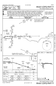
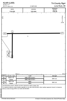


KLNR - Tri-County Rgnl
Located in Lone Rock, United States
ICAO - LNR, IATA - LNR
Data provided by AirmateGeneral information
Coordinates: N43°12'43" W90°10'47"
Elevation is 717 feet MSL.
Magnetic variation is 00° East View others Airports in Wisconsin
Operational data
Special qualification required
Current time UTC:
Current local time:
Weather
METAR: KLNR 191756Z AUTO 28020G30KT 10SM SCT070 11/M04 A3007 RMK AO2 PK WND 28036/1721 SLP180 T01061044 10106 20022 58013
Communications frequencies: [VIEW]
Runways:
| RWY identifier | QFU | Length (ft) | Width (ft) | Surface | LDA (ft) |
| 09 | 89° | 5000 | 75 | ASPH | |
| 27 | 269° | 5000 | 75 | ASPH | |
| 18 | 180° | 1850 | 60 | ASPH | |
| 36 | 360° | 1850 | 60 | ASPH |
Airport contact information
Address: Lone Rock United States