


KLMS - Louisville/Winston County
Located in Louisville, United States
ICAO - LMS, IATA - LMS
Data provided by AirmateGeneral information
Coordinates: N33°8'46" W89°3'45"
Elevation is 574 feet MSL.
Magnetic variation is 00° East View others Airports in Mississippi
Operational data
Special qualification required
Current time UTC:
Current local time:
Weather at : KSTF - George M Bryan ( 38 km )
METAR: KSTF 271955Z AUTO 17016G23KT 10SM FEW046 FEW055 SCT070 28/19 A3008 RMK AO2
Communications frequencies: [VIEW]
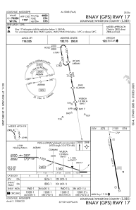
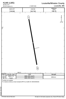
Runways:
| RWY identifier | QFU | Length (ft) | Width (ft) | Surface | LDA (ft) |
| 17 | 170° | 4669 | 75 | ASPH | |
| 35 | 350° | 4669 | 75 | ASPH |
Airport contact information
Address: Louisville United States