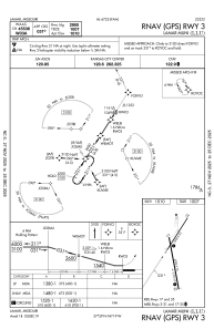


KLLU - Lamar Muni
Located in Lamar, United States
ICAO - LLU, IATA -
Data provided by AirmateGeneral information
Coordinates: N37°29'9" W94°18'43"
Elevation is 1009 feet MSL.
Magnetic variation is 02° East View others Airports in Missouri
Operational data
Special qualification required
Current time UTC:
Current local time:
Weather at : KPTS - Atkinson Muni ( 37 km )
METAR: KPTS 180655Z AUTO 17008KT 10SM CLR 20/14 A2985 RMK AO2 T01960140 PWINO
Communications frequencies: [VIEW]
Runways:
| RWY identifier | QFU | Length (ft) | Width (ft) | Surface | LDA (ft) |
| 03 | 33° | 2900 | 60 | OTHER | |
| 21 | 213° | 2900 | 60 | OTHER | |
| 17 | 169° | 4000 | 75 | CONC | |
| 35 | 349° | 4000 | 75 | CONC |
Airport contact information
Address: Lamar United States