


KLIT - Bill And Hillary Clinton Ntl/Adams Fld
Located in Little Rock, United States
ICAO - LIT, IATA - LIT
Data provided by AirmateGeneral information
Coordinates: N34°43'46" W92°13'29"
Elevation is 266 feet MSL.
Magnetic variation is 00° East View others Airports in Arkansas
Operational data
Special qualification required
Current time UTC:
Current local time:
Weather
METAR: KLIT 050053Z 00000KT 10SM SCT030 SCT160 22/18 A2997 RMK AO2 SLP148 T02170183 $
TAF: KLIT 042320Z 0500/0524 VRB05KT P6SM VCTS SCT020 BKN050CB BKN250 TEMPO 0500/0504 5SM -TSRA BR BKN025 OVC040CB FM051300 09005KT 6SM -SHRA BR VCTS BKN015 OVC025CB PROB30 0515/0521 2SM TSRA BR BKN008 OVC020CB FM052100 14006KT 4SM BR VCSH SCT015 BKN040 OVC100
Communications frequencies: [VIEW]
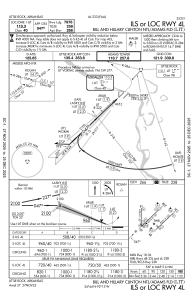
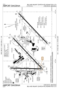
Runways:
| RWY identifier | QFU | Length (ft) | Width (ft) | Surface | LDA (ft) |
| 04L | 47° | 8273 | 150 | CONC | 7976 |
| 22R | 227° | 8273 | 150 | CONC | 8273 |
| 04R | 47° | 8251 | 150 | CONC | 7200 |
| 22L | 227° | 8251 | 150 | CONC | 7200 |
| 18 | 182° | 6224 | 150 | CONC | 6060 |
| 36 | 2° | 6224 | 150 | CONC | 6060 |
Airport contact information
Address: Little Rock United States
