


KLFI - Langley Afb
Located in Hampton, United States
ICAO - LFI, IATA - LFI
Data provided by AirmateGeneral information
Coordinates: N37°4'58" W76°21'38"
Elevation is 8 feet MSL.
Magnetic variation is -10° East View others Airports in Virginia
Operational data
Special qualification required
Current time UTC:
Current local time:
Weather
METAR: KLFI 030455Z AUTO 22007KT 10SM CLR 23/18 A2997 RMK AO2 SLP155 T02280181 402870148 $
TAF: TAF KLFI 030100Z 0301/0407 VRB06KT 9999 FEW190 QNH2998INS BECMG 0317/0318 07015G20KT 8000 BR FEW010 SCT020 QNH2999INS BECMG 0321/0322 08012G18KT 8000 BR SCT005 BKN015 QNH3010INS BECMG 0405/0406 06009KT 6000 BR BKN005 OVC010 QNH3009INS TX19/0320Z TN14/0312Z
Communications frequencies: [VIEW]
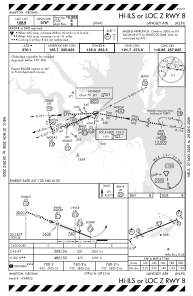
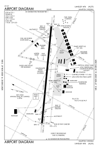
Runways:
| RWY identifier | QFU | Length (ft) | Width (ft) | Surface | LDA (ft) |
| 08 | 0° | 10002 | 150 | CONC | |
| 26 | 0° | 10002 | 150 | CONC |
Airport contact information
Address: Hampton United States