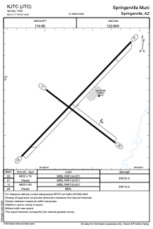


KJTC - Springerville Muni
Located in Springerville, United States
ICAO - JTC, IATA -
Data provided by AirmateGeneral information
Coordinates: N34°7'46" W109°18'39"
Elevation is 7055 feet MSL.
Magnetic variation is 12° East View others Airports in Arizona
Operational data
Special qualification required
Current time UTC:
Current local time:
Weather
METAR: KJTC 231055Z AUTO 22010KT 10SM CLR 06/M04 A3014 RMK AO2
Communications frequencies: [VIEW]
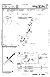
Runways:
| RWY identifier | QFU | Length (ft) | Width (ft) | Surface | LDA (ft) |
| 03 | 44° | 8422 | 75 | ASPH | |
| 11 | 128° | 4603 | 60 | ASPH | |
| 21 | 224° | 8422 | 75 | ASPH | |
| 29 | 308° | 4603 | 60 | ASPH |
Airport contact information
Address: Springerville United States