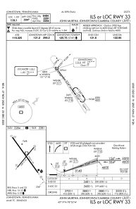
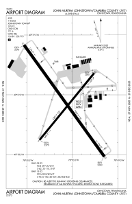


KJST - John Murtha Johnstown/Cambria County
Located in Johnstown, United States
ICAO - JST, IATA - JST
Data provided by AirmateGeneral information
Coordinates: N40°18'56" W78°50'5"
Elevation is 2284 feet MSL.
Magnetic variation is -10° East View others Airports in Pennsylvania
Operational data
Special qualification required
Current time UTC:
Current local time:
Weather
METAR: KJST 200054Z AUTO 20003KT 10SM OVC020 12/11 A2998 RMK AO2 RAE2358 SLP153 P0000 T01220111
TAF: KJST 200102Z 2001/2024 27008KT P6SM VCSH OVC020 FM200300 31009KT P6SM SCT020 OVC050 FM200600 30006KT P6SM BKN100 FM201200 28008G17KT P6SM SKC FM201500 27016G22KT P6SM SCT050
Communications frequencies: [VIEW]
Runways:
| RWY identifier | QFU | Length (ft) | Width (ft) | Surface | LDA (ft) |
| 05 | 39° | 4387 | 100 | ASPH | 4387 |
| 23 | 219° | 4387 | 100 | ASPH | 4387 |
| 15 | 144° | 7004 | 150 | CONC | 6698 |
| 33 | 324° | 7004 | 150 | CONC | 6484 |
Airport contact information
Address: Johnstown United States
