


KJHN - Stanton County Muni
Located in Johnson, United States
ICAO - JHN, IATA -
Data provided by AirmateGeneral information
Coordinates: N37°35'7" W101°43'56"
Elevation is 3325 feet MSL.
Magnetic variation is 07° East View others Airports in Kansas
Operational data
Special qualification required
Current time UTC:
Current local time:
Weather
METAR: KJHN 251055Z AUTO 15013KT 10SM OVC017 18/17 A2985 RMK AO2 T01770173
Communications frequencies: [VIEW]
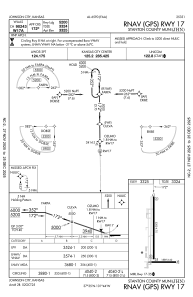
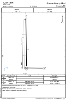
Runways:
| RWY identifier | QFU | Length (ft) | Width (ft) | Surface | LDA (ft) |
| 08 | 90° | 1889 | 60 | ASPH | |
| 17 | 180° | 5200 | 75 | CONC | |
| 26 | 270° | 1889 | 60 | ASPH | |
| 35 | 0° | 5200 | 75 | CONC |
Airport contact information
Address: Johnson United States